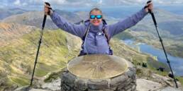
You’ll likely already be familiar with Google’s Street View technology featured in Google Maps and Google Earth which provides interactive 360° panoramas of streets around the world. But what you might not know is that all six of Snowdon’s main footpaths are also featured!

In 2015 Snowdon wardens and volunteers used Google’s trekker backpack fitted with a 15-angle lens camera to walk the paths and record images which have since been incorporated into Google Street View. So you can now reach the summit of Snowdon from the comfort of your own home. It’s not quite the same we know but it does provide an amazing resource to help you prepare for your actual ascent.
To get started, visit www.google.co.uk/maps from your computer, table or mobile device and search for ‘Snowdon’. We’ve included a few examples below. Try double clicking or double tapping on the images to follow the paths.
The start of the Llanberis Path just outside the village of Llanberis.
The beginning of the Pyg Track leading out of the car park at Pen-y-Pass.
The final stretch of the Watkin Path as is a tough scree climb to the summit.